|
Enchanted Forest Nature Sanctuary 444 Columbia Blvd., Titusville Florida 32780 |

|
By Dave Rich
Introduction:
The Addison/Ellis canal is an important part of the history of the Enchanted Forest Nature Sanctuary. Several attempts have been made to research a history of the canal -- to no avail. Recently members of the North Brevard Historical Society searched their museum library and found no written records They do have four photographs; one of a camp for the workers, two of equipment used to dig the canal, and one of a small boat in a finished section of the canal. It is rumored that information is in private hands, and hopefully that will become available for study.The following is an attempt to set down what I have uncovered during my several years of activity with the Friends of the Enchanted Forest and my interest in history. There is no claim to academic research or documentation. It is hoped that this article will stimulate efforts that will make a more substantiated, accurate history available. I appreciate any help offered, and shall endeavor to update this article as more information is provided or unearthed.
The Addison Canal was reportedly dug in 1912-13.
Click on an image to view an enlargement. The aerial images were provided, as marked, by Stan Tribble of Port St. John. They were taken in 1994. Edgar W. Ellis put together a consortium of developers that had hoped to drain the marshland in the St. Johns River valley and sell it to farmers to grow crops. The canal would also be used to transport the crops and other goods. Some say that the canal was designed to divert floodwaters from the valley to the lagoon. Others say the plan may have been to connect the St. Johns River with the Indian River itself, but that is generally doubted.
This consortium was known as "Titusville Fruit and Farm Lands Company," and was incorporated by Mr. Ellis, C.J. West, and J.H. Beckwith in 1911. They aquired 22,500 acres, mostly in the western portion of the old Delespine Grant. The canal's course is pretty much east from the St. Johns River marshes through The Great Outdoors RV Resort, along the south border of the Blue Heron Water Reclamation Facility, through the Windover Development. Just west of Grissom Road it cuts north east to the Enchanted Forest where it turns due east, ending just past the scrub/coquina ridge in the Addison Creek. The plan was to follow the creek, heading north easterly, ending up in the Indian River at Addison Point. Various documents record it as the Addison Canal or the Ellis Canal.
The marshland and sand ridges proved no problem for the equipment of the day. You can see a nice wide Addison Canal flowing under I-95, just south of Exit 215. One story relates that the equipment that was used came from the Panama Canal Project that had been abandoned by the French engineers.
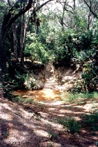
The canal was never completed. It met its fate in the Enchanted Forest. The coquina rock ridge, which goes north-south through the center of the forest, proved to be an unsurmountable obstacle.
They made considerable progress, as the gorge we see today shows. It appears that their equipment broke down, and that it took longer than anticipated to dig through the ridge. The consortium went broke. They were able to re-finance once, but the second time they had to abandon the project. The canal never reached a useful depth and construction ended just east of the ridge in Addison Creek.
The spoil from digging the canal was piled up in what is now a muscadine grape vine covered field east of the ridge, stretching south over the lime trail. That spoil was eventually used in the 1940's as fill for the runways at the Naval Air Station which is now Space Coast Regional Airport.
Photos of Photographs in the North Brevard Historical Museum
Click on a picture to see an enlargement. Use the BACK button of your Browser to return.There was quite a flow of water through the canal before it was filled for construction of the McDonald Douglas plant and route 407. People used to swim and fish in it, but it may have been dammed to make that possible. Now there is a small, steady flow of water.
The water now originates from the pond next to Route 405, directly in front ot the plant. There is a steady flow of water, even in dry times, from that pond, through a large culvert under the road. It is augmented by a steady flow from the marshy area north of the canal, just west of the ridge. The canal caused, and continues to cause, a significant disruption of the hydrology of the area as all water west of the ridge used to flow to the St. Johns River.
It is interesting to contemplate what might have happened had the canal succeeded. Would the farming have caused a salt water intrusion, much like what has happened in the Lake Okeechobee and Everglades areas? There are salt aquifers under parts of our area, and many shallow wells were abandoned by early settlers because of the salt content of the water.
It cost about $43,000,000 to build the Okechobee and Everglades canal systems in the 1940's. The US congress recently voted to spend about $8,000,000,000 to reclaim a portion of it. Were we spared such a fate by our coquina ridge? Would much of our area even be habitable if it had succeeded?
In the 1960's a cut was made by the Apollo Motorcycle Club in the place known as the "Swings." They had a trail system that went from Mims to Canaveral Grove. In the forest it apparently followed the red trail to the Magnolia loop across a bridge near the south-east corner and then on south. They constructed other trails in the forest area too.
The Swings area looking south. One story is that during a popular "Pumpkin Run" motorcross race an out of state cyclist stopped at the checkpoint in the forest and said: "This is the most enchanting place that I have ever ridden."
The "Swings" still holds a cable (as of 2000) that was strung from a branch about 100 feet above the canal. A rope was attached to the loop at the end and people would swing from one side to the other. A very exciting ride! It was also a lesson of weight versus strength, with a number of young people going home with broken bones. There were several swings along the canal gorge.
The "Swings" is also a particularly beautiful spot. It has hosted many family gatherings and church picnics over the years. One halloween local kids lined the road along the canal to the "Swings" with carved, lighted pumpkins.
An End to the Swings
Years ago, maybe 1974, I became what was the final chapter of the swings. It became a popular story back then. Attending Titusville High School, myself and a friend cut classes and went out to the swings. Back then, quite a hike.Riding double on the swing, it broke. We fell into the empty creek, containing broken glass, rocks and logs. I was on the bottom and hit first, breaking all the bones in my left leg to my hip and cutting off most off my pinkie. My "friend" panicked and left me there in the heat, bloody and broken. I passed out trying to climb up the bank, awakening in Jess Parrish (hospital). I was unconscious all day when a motorcyclist found me. The ambulance had a rough time getting to me. I was hospitalized and in a wheel chair for many months.
The city found out and cut off the original "swing" worried about liability issues and the health of other wayward youth, skipping school! Big news for Titusville back in the early 70's! I still visit the swing even today and have told my daughter the story of the "swing".
Martin Brenner
One exciting event was watching an old car pushed off the edge into the canal. The drop is over 40 feet. Some of the parts remain to this day. It's vandalism today, but back then most any out of the way place was considered a valid dumping ground by many.
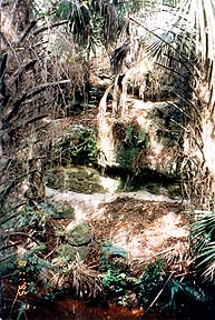
Trash in the gorge. The gorge that was dug through the ridge has revealed valuable information about the formation of the ancient coquina ridges and dunes. One can see stratification from the days when the ridge was a sand dune on the Atlantic Coast, perhaps 120,000 years ago.
If you look closely, you will see embedded shell much like what you see on today's beaches. Some of the rock is made with very finely ground seashells, other places show the shells to be very coarse, even complete. Some places the coquina formed very solidly, some places it is softer and subject to more erosion, and some places it didn't form into rock at all leaving little caves where sand washed out during the digging.
Stratification in the gorge. Because the gorge is much more dark, cool and damp than the surrounding area, a whole unique ecosystem has developed in there. You will find lizards, plants and other life that is unique, in this area, to the canal gorge. Did winds, birds, storms bring them here?
The Ellis/Addison Canal is a unique part of our history, and a beautiful place to contemplate man's interaction with the environment.
 This picture can be enlarged by clicking on it. Use BACK to return. |
 |
 |
| Looking west from under the Windover Way (west) bridge. |
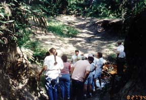
Geology field trip at the "Swings." | The old Apollo Motorcycle Club bridge |

| |||||||||
| |||||||||
|
• HOME
|
Keeping you up-to-date with what is available and what is going on in the Titusville, FL area. |
Contact the webmaster for most anything by CLICKING HERE |
|||||||
| the North Brevard Area | |||||||||
|
Produced by Peak Performance Co. nbbdcom@gmail.com Last updated: 5/12/18 — © 1996 - 2016 |
|||||||||
|
• Info on participating in this directory.
• Info for non-profits. • We can register, produce, host and market your Internet presence. |
|||||||||

EYES ON PAGE is what you seek when promoting your business or activity. In 2017 the webpages of the NBBD were visited 1,078,946 times - that averages 2,956 times a day. Won't some of them be seeking what you offer?
|
|||||||||